New England Nutrient Managment Decision Support Tool
Reference Scenario
Comparison Scenario
Nutrient Difference (Comparison - Reference)
Crop Yield Percent Change (Comparison vs. Reference)
Absolute Exports by Scenario
Additional Resources
Get more information about these Best Management Practices
Modeling Approach and Data Sources
SWAT+ (Soil and Water Assessment Tool+) is a widely used watershed model developed by the USDA Agricultural Research Service, Texas A&M AgriLife Research, and collaborating institutions. SWAT+ simulates the quantity and quality of water within real-world watersheds under different land uses and land management practices, making it well suited for evaluating thousands of Best Management Practice (BMP) scenarios.
The New England Nutrient Management Decision Support Tool was built using three Connecticut watersheds with sufficient U.S. Geological Survey monitoring data to calibrate the models to observed streamflow and nutrient concentrations. We used built‑in management operations within SWAT+ to represent a suite of BMPs commonly applied to farmland in New England. To account for uncertainty in watershed behavior and model calibration, each watershed was run using five unique parameter sets. This produced 15 independent simulations (3 watersheds × 5 parameter sets) for every BMP scenario. The error bars shown in the tool’s bar graphs represent the range of responses across these simulations, including the minimum, maximum, and mean nutrient export or crop yield.
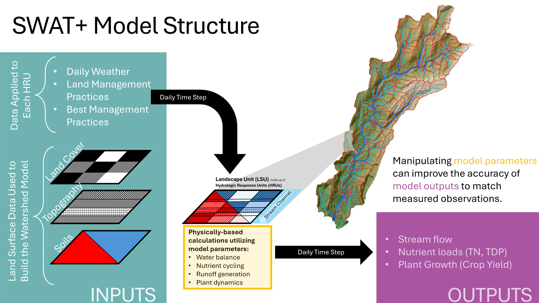
This diagram shows how the SWAT+ model represents and simulates a watershed. The model begins with a digital elevation map to identify where water flows and how the watershed is divided into smaller subbasins. Land cover, soil type, and slope are combined to form Hydrologic Response Units (HRUs), which are the basic areas where SWAT+ calculates water movement, nutrient cycling, and plant growth. Daily weather and farm management inputs drive these processes and move water and nutrients downslope into the stream network. The model produces outputs such as streamflow, nutrient loads, and crop growth. Model parameters are adjusted during calibration so that these outputs match real measurements collected at USGS monitoring stations.
This tool compares nutrient losses between two crop‑field management scenarios for a generic farm in New England. Because SWAT+ cannot capture all of the unique characteristics of any individual farm, the nutrient exports shown here should be interpreted as generalized estimates of how BMPs influence nutrient loss and crop performance under typical regional conditions, rather than precise predictions for a specific field.
A detailed description of the modeling framework, calibration process, and BMP scenario design will be available in a forthcoming publication. Once published, a citation and link will be added here.